Do You Know What the Actual Boundaries of The Bay Area Are?

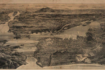
PG&E service map for The Bay Area from 1930
You can’t ‘rep The Bay,’ if you don’t even know what it is.
Everyone from The Bay loves to say they’re from “The Bay”. It’s almost a rite of passage. You’re not really from here if you haven’t obnoxiously shamed someone for their lack of ability to recite “Feeling Myself” by Mac Dre without error. Despite this regional pride, there seems to be a complete lack of knowledge or insight into what and where the Bay Area actually is. Is Sacramento The Bay? How about Santa Cruz, San Jose, Antioch, Fairfield, Santa Rosa and Stockton? Do they count? And what exactly makes a place in The Bay Area part of The Bay Area? Some have said “If you don’t have a BART station, you’re not part of the Bay Area.” Others have said “If you can’t see the actual water, you’re not in the Bay.”
So, in order to clear confusion (and to prevent you from sounding like a fucking moron at the next house party you attend) I’m going to explain very basically (yes, basic enough even for you, my ‘YAY AREA’ purist) what geographically defines The Bay Area and explain why there has been so much confusion around such a simple topic.
The Water
To know what The Bay Area is, first we must explore the water of the Bay and its various sources. Yes, we have to have technical understanding. The water, from a very dry, bureaucratic perspective, is actually called the “San Francisco Bay Delta Watershed.” That’s a mouthful. Can you imagine E-40 saying boastfully that he reps the San Francisco Bay Delta Watershed? You can’t? Good. Like, really dwell on that for a moment… “WE GAMED UP IN THE SAN FRANCISCO BAY DELTA WATERSHED AREA OUUUU.” Doesn’t flow well, does it? Anyway, back to the water. The Bay, despite being called “The Bay”, is actually a large delta composed of many bodies of water unified as one. There’s actually three equally important bays that are essential and definitive in relation to the region. Those bays are San Francisco Bay, San Pablo Bay, and Suisun Bay.
San Francisco Bay
Now, you’re probably asking why are those bays differentiated? Well, it boils down to primary water source. San Francisco Bay is primarily salt water which flows from its source, the Golden Gate Strait, with some fresh water as a result of rivers, most of which are flowing in from the north. That’s where San Pablo Bay, which is the northern extension of San Francisco Bay, comes into play.
San Pablo Bay
San Pablo Bay, separated from San Francisco Bay by the San Pablo Strait, is a narrowing of the bay near the Richmond-San Rafael Bridge that allows fresh water from a multitude of rivers flow into SF Bay. This opening also allows salt water into San Pablo and Suisun Bay.
Suisun Bay
Speaking of fresh water, let’s talk about Suisun Bay. Suisun Bay receives most of its water from the Sacramento and San Joaquin rivers. This river water flows into San Pablo Bay via the Carquinez Strait near Vallejo, where it also picks up water from the Napa River via the Mare Island Strait. The Petaluma river also flows into San Pablo Bay about ten miles to the northwest.
So, to make this a little easier to digest, think of it like this: San Francisco Bay = a lot of ocean water + some river water. San Pablo Bay = a blend of ocean and river water. Suisun Bay = a lot of river water + some ocean water. See why they’re named differently? There’s also smaller bays like Grizzly Bay and Richardson Bay, but they don’t really matter.

Map of the nine-county Bay Area courtesy of ABAG (Association of Bay Area Governments)
The Region
Now that we got that out of the way, let’s talk about this Bay Area everyone seems so fucking confused by. The Bay Area is not defined by cities that touch the Bay. It’s defined by counties; particularly 9 counties that touch one of the three main bays. Those are Alameda, Contra Costa, Marin, Napa, San Francisco, San Mateo, Santa Clara, Solano, and Sonoma counties.
That’s not to say there isn’t an awkward exception. It’s the Bay Area, our entire existence is based on awkward exceptionalism. The region is rich as fuck and San Francisco is a dystopian nightmare, but that’s a different article. The awkward exception in the 9 counties definition is Napa County, which doesn’t technically touch San Pablo Bay. It’s separated by a tiny sliver of marshland, but San Francisco wants that wine country clout to be associated with them, so fuck it, they’re in too.
Another thing to remember is that the bay is big as fuck. It goes from Highway 37 to the north, all the way to San Jose on the southern end and Pittsburg to the far east. Not far from inland delta port cities like Stockton. In essence, the body of water that our region is defined by is big as fuck. So, even if something is hella far from you, it doesn’t mean it’s not The Bay Area… Also, to the people that say if it doesn’t have BART, it’s not The Bay, ask them “which came first, the water or the trains?” Watch their heads explode.
The Conclusion
I’m done educating you guys on basic ass shit. Why does a loser who makes memes have to clean up the mess created by our shitty public schools? That’s for a different article. Just know the next time some moron comes to your house party and tells you San Jose isn’t The Bay, show them this article and tell them to shut the fuck up.
IF YOU WANT TO LEARN MORE ABOUT THE BAY AND NORTHERN CALIFORNIA’S SHORELINE, CLICK THIS LINK