The Great Highway looking south from Sutro Heights. Image courtesy Wikimedia Commons user, Creative Commons.
Letting go of the Great Highway will be subject of a ballot measure this upcoming election. What the seaside avenue means to San Franciscans changes every generation. It’s been the site of a railway track, an amusement park, a paved thoroughfare, a pedestrian promenade. The Great Highway’s future could see it returned to the sands tirelessly trying to reclaim it. Here’s why that might be a good thing.
The Great Highway requires constant upkeep.

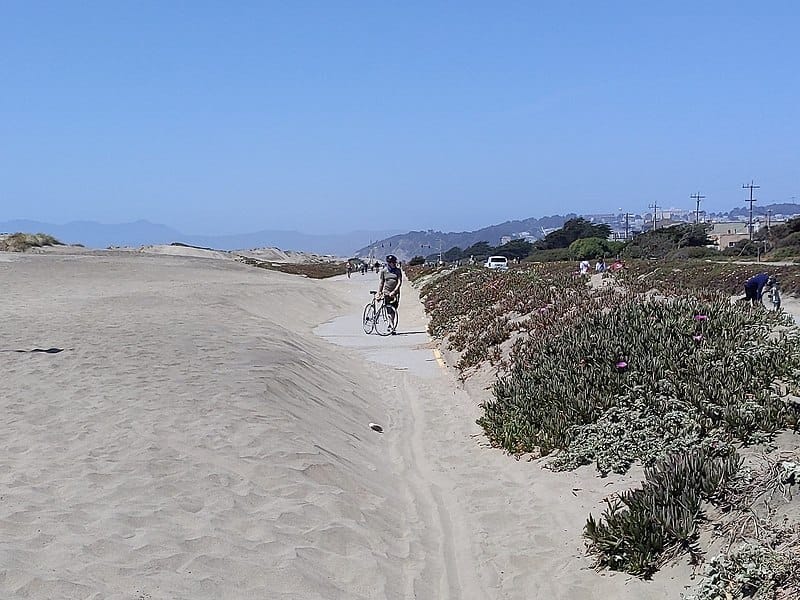
The Great Highway partially buried in sand. Image courtesy Wikimedia Commons user Jef Pozkancer, Creative Commons.
Proponents for the highway’s permanent closure point to high maintenance costs and the futility of regular sand dune removal. The beachside roadway closes for cleaning roughly 27 times per year, according to a figure from 2020. It has weathered harsh winter storms, ninety-five years of automobile traffic, and gradual coastal erosion. At the mercy of roaming sands and high winds, the often buried lanes represent an uphill battle against nature.
It’s already happening south of Sloat Boulevard.
Skirting the San Francisco Zoo, an extension of the Great Highway steers the roadway closest to the shore. Coastal erosion and rising seas already reclaimed a parking lot along this portion. Chronic weathering shrinks the pavement’s lifespan as evidenced by its pitted, potholed surface. If you’ve ever driven that often fog-enveloped stretch, you know what I mean.
Even if this section stayed open, its modest height and proximity to the sea means its days are numbered. What’s worse, on the inland side of the road lies a vulnerable wastewater treatment facility. Plans for a protective seawall include the installation of a public plaza and an emergency vehicle lane to Skyline Boulevard. The extension of the Great Highway south of Sloat to Skyline Boulevard/State Route 35 should close by early 2026, by which time the Highway’s ultimate fate will have been decided.
Currently, the Great Highway virtually bypasses the Sunset District.
Advocates for the highway’s preservation claim that its closure would stifle north–south travel in the Sunset when it doesn’t serve the Sunset at all. Did you know the Great Highway was split into Upper and Lower parts? The upper portion is the four-line thoroughfare connecting Cliff House at Lands End to Sloat Boulevard down south. That road engages with the Richmond District, receiving the termini of Balboa and Fulton Streets, but not the Sunset District. Inaccessible between Lincoln and Sloat Boulevards, the Upper GH skips the Sunset, restricting intra-district, north–south travel to the Lower Great Highway.
One Text a Week: All the Best Bay Area Events * indicates required Email Address *SMS Phone Number Broke-Ass Stuart - By providing your phone number, you agree to receive promotional and marketing messages, notifications, and customer service communications from Broke-Ass Stuart. Message and data rates may apply. Consent is not a condition of purchase. Message frequency varies. Text HELP for help. Text STOP to cancel.See terms.
It may have outlived its usefulness.
When City Hall first closed the Great Highway, we saw what a draw a shoreline park could be. A 17-block stretch of road—the portion that bypasses the Sunset—became the first park of its kind in the state. Here you can walk, jog and ride your bicycle on flat, continuous pavement, a luxury in San Francisco. Other flat strides include Crissy Field and the Embarcadero. Both these routes interact heavily with traffic and MUNI vehicles. Not the Great Highway. The shift in catering from cars to people has been revelatory.
A similar transformation occurred along the downtown waterfront following the 1989 Loma Prieta earthquake. The Embarcadero Freeway was a double-decker structure that linked Chinatown and North Beach to the Bay Bridge. After the similar Cypress Structure collapsed in Oakland, Mayor Art Agnos had the Embarcadero Freeway torn down. Repurposing highways in San Francisco isn’t a foreign concept. It’s been done before, usually for the better.
“The decision to tear down the Embarcadero Freeway was controversial thirty-five years ago, just as the decision about the Great Highway is today. I wonder,” City Supervisor Joel Engardio told NBC Bay Area, “will the Great Highway for cars become forgotten as the old Embarcadero freeway? I believe our kids and generations after them won’t be able to imagine San Francisco without an oceanside park.”
The post San Francisco’s Great Highway Could Close For Good appeared first on Broke-Ass Stuart's Website.


